• About
  • Work
  • Blog
  • Contact
Menu

Little Leaf Photography

Creative Photography and Design
  • About
  • Work
  • Blog
  • Contact

B l o g

Welcome to my blog page.

Please click “older posts” which will jump-start you to the bottom of the page, to find all previous posts.

Enjoy!

yak.jpg

Folding Upwards Part Five: Namche to Pangboche

March 23, 2019

I had conceded to hiring a porter

as the journey up to Namche had shown me this was no easy trek. For $20USD a day, I had the company of Jeet, a Namche local who had worked as a porter many times to EBC. He knew teahouse owners, where to find the best coffee and best of all he was amazingly helpful and thoughtful.

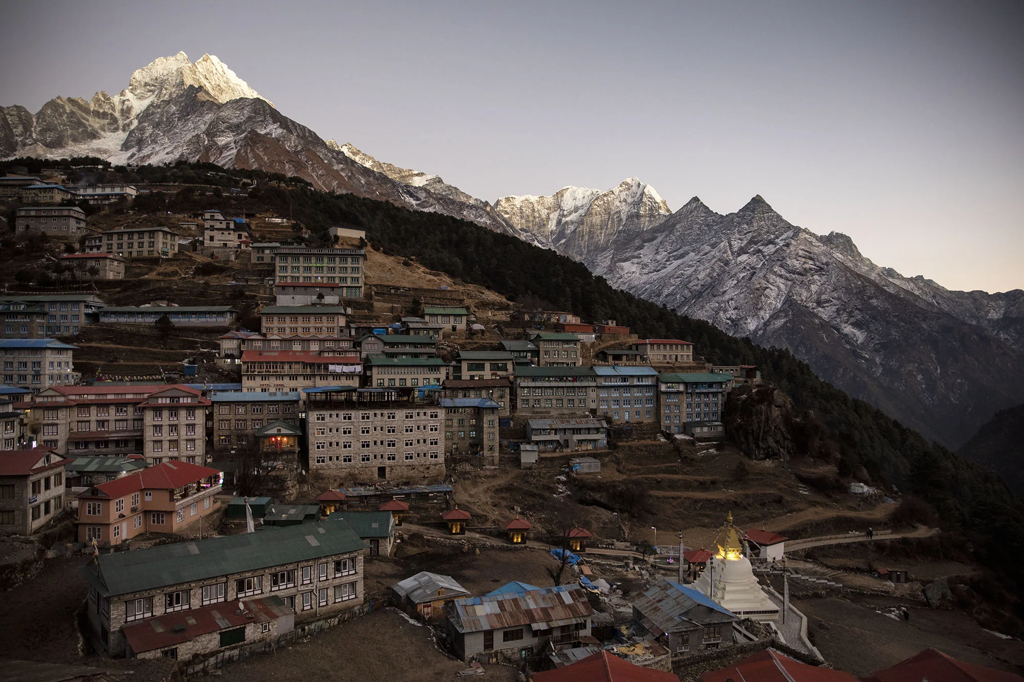
Pangboche was our aim

and so off we went, slowly ascending on Namche’s hundreds of steps out into a grey gloomy morning.

The ever-smiling Jeet with my pack on and his inside it!

The ever-smiling Jeet with my pack on and his inside it!

Once the ascent out of Namche is complete, the path sidles around the mountains on a wide, flat-ish very pleasant trail that provides commanding views of Ama Dablam and show-cases sweeping vistas into the valley below Namche. I could see the double swing bridges far below with the Dudh Kosi flowing beneath.

The track was busy with people - not all tourists like me, but mainly with ‘locals’ ferrying goods, walking behind yaks - seemingly a bustling main highway. The track had an extremely steep drop-off on one side to the river below, and you very quickly learn to stick to the mountain side of the trail especially when a yak train approaches.

Jeet pointed out Tengboche perched on a hill in the distance. I quipped that it did not seem too far away (which actually it wasn’t - only a few kilometres; however, I could see we would need to descend to the valley below to cross the river and then climb again in order to reach the small village. Oh how I looked forward to that climb … not.

We walked along at a fairly reasonable pace until reaching the foot of the climb that would take us to Tengboche. At the base of the hill, across a bridge, was a small booth inhabited by a khaki-clad young man who was checking permits. I used this as an opportunity to gather my wits, drink some water and prepare for the steep trek ahead.

Tengboche sits at 3860m

and is famous for its monastery (Dawa Choling Gompa) where tourists can walk the grounds or even attend meditation early in the morning alongside the Buddhist monks who reside here.

I was originally going to stay in Tengboche the night, but decided to move upwards to Pangboche with the plan to ascend to Ama Dablam base camp as an acclimation trek, necessitating a two night stay at Pangboche. I felt the elevation difference between Namche and Tengboche was not enough to warrant a night there.

The haul up to Tengboche was again a sufferfest for me. Step-step-STOP; step-step-STOP; step-step-STOP

and when I finally arrived, Jeet was already relaxing in the teahouse with his ginger tea and ready to order my lunch for me.

Looking back down to the entrance into Tengboche.

Looking back down to the entrance into Tengboche.

As I sat eating my lunch, shouting erupted from outside.

Jeet rushed out to see what was going on and I followed. A group of men had a man bailed up and pinned against the stone wall. They were shouting at him and things escalated quickly as heated debate about something took place. Fists were thrown. I started to worry. A guy in a military style uniform yielding a massive rifle stood silently to the side, watching.

I asked Jeet what it was all about and he informed me the man was accused of stealing something. Shortly after local ‘police’ (man in uniform with gun) had him handcuffed (with rope) and sitting in the teahouse where I resumed my lunch-eating. The man sat muttering loudly.

Jeet came and sat with me “good decision not to stay here” he said.

I couldn’t help but be aware of the juxtoposition of being at the world’s most famous monastery amidst a violent outbreak. Surreal.

tangboche1_small.jpg
tangbochetemple.jpg
tengboche.jpg

The trail from Tengboche slopes away from the village

through rhododendron trees, which I imagined in flower would have been exceptionally stunning; for now they waited for a warmer season, retreating into spindly barren twigs for the winter. Across the valley we could see Phortse, enveloped in greyness, accentuating the chilling cold of the Nepal winter.

phortse.jpg

As Jeet and I continued, I became aware

of how dark, gloomy and cold it was. I was beginning to get a deep sense of how isolated this part of the world was, and how far I was from all the things I took for granted in my life. There is nothing like a good walk to sort some of this stuff out.

As we approached a swing bridge, I could see its former counterpart, collapsed into the valley, highlighting again the tenuous relationship of man in nature. This strong robust bridge could not hold against the conditions here. If a bridge is out, the impact on local villages must be enormous..

At the end of the swing bridge I noticed a tall man with long hair holding what appeared to be numerous bags. As I approached I could see he had an enormous pack, plus several smaller bags slung over his shoulders. He had colourful feathers woven into his hair and was sporting a camera with a long telephoto lens, trying to capture the Himalayan Thar that were gazing back at him. He heard me approach and delightfully exclaimed “are you following me?!”

I laughed and queried his choice of hauling heavy camera equipment up here. He informed me he had four lenses and two camera bodies with him. He was a strapping man - well over 6 foot 4 or 5 and I figured he had the brute strength to lug all this kit around. I asked him what his plans were and he said he had no plans, but thought he may do the Three Passes. I was in awe of this mammoth of a man.

So were the Thar.

Himalayan Thar

Himalayan Thar

brokenbridge.jpg
brokenbridge_2.jpg
You can see a Thar just to the left of the bridge

You can see a Thar just to the left of the bridge

“My name is Joy”

he said, with an extended hand. He told me I should check out his instagram page - something about ‘spiritual wilderness’ - and how he had come to the Himalayas 17 years ago to just wander around. He couldn’t believe how things had changed - “mostly the bridges” he said, “thank god”.

Joy informed me he was going to Pangboche that night and maybe we would catch up there. I wasn’t sure if I should be looking forward to that or not, but certainly he had camera gear and photos i was eager to look at.

The track to Pangboche from Tengboche is a gradual ascent but I was beginning to feel as if my legs were tiring. When we arrived in Pangboche, I was cold and tired and looking forward to a decent meal. The teahouse was one of several in Pangboche but one of the few open for the straggling tourists venturing this way in early winter.

Pangboche is at 3985m in elevation

and is often used as the launch pad for Ama Dablam base camp as the trail starts just outside the village.

Ama Dablam (6812m) oversees this part of the Himalayas and is a steady presence right through to Dingboche. It feels as if you are walking around Ama Dablam, rather then walking to EBC; a treat I absolutely loved whilst in this part of the Himalayas as it is such an enigmatic mountain.

The mysterious Ama Dablam, hiding behind cloud.

The mysterious Ama Dablam, hiding behind cloud.

… and there she is.

… and there she is.

Pangboche was alive with the sound of helicopters.

It was the first time I had really noticed them. here they arrived and left with a scary regularity - ferrying sick tourists back to Kathmandu or Lukla for treatment from the high altitude. I felt grateful not to have felt any indication of altitude sickness - just tired legs; I knew to take it slow, pace myself and to take my time going up. I was in no rush.

The tea house in Pangboche (the name escapes me) was my worst experience so far in Nepal. My room was next to a toilet - traditional Nepal style of course - but people obviously had aiming issues, as urine and shit stained the wooden footpads. The smell was vomit-inducing and leached into my room. I decided to do what many people advised and use a make-shift ‘she-pee’. This felt like a feral thing to do for me, but was far more hygienic than using the toilet unless for number two’s. These are the things you need to think about when in the mountains - again - stuff we take for granted in New Zealand. I also couldn’t brush my teeth as there was no running water. My water bottle was frozen solid in the morning necessitating buying hot water - which the tea house charges exorbitant prices for. They were onto a good thing. The village had an air of cold dampness and gloom about it. I didn’t want to stay two nights. I told Jeet, “no Ama Dablam base camp - we carry on to Dingboche tomorrow”.

pangboche.jpg
pangboche1.jpg
pangboche2.jpg

“Oh there you are!”

I heard that familiar American East Coast inflection that I had encountered at the bridge with the Thar.

“I wondered if you would be staying here. You wanna come up to the old Gompa with me?” Joy said with way too much energy and enthusiasm; “the monks are there - you should totally come with me”.

I was thinking I should totally lie down and just totally get a coffee and totally eat something before I did anything at all. He (Joy) pointed out the trail to the Gompa - up steeply out of Pangboche. I refused his very kind offer, making up excuses of having to edit my photos.

Later that evening, I ate in a dining room full of trekkers - there were at least ten of us all from different parts of the world, sharing our stories and backgrounds; our experiences in Nepal and on the trail so far; the ‘what to do’s and what not to do’s”. I sat there thinking about how wonderful this aspect of trekking was. I had come to Nepal to be on my own. I had resisted taking a porter, I wanted so badly to be on my own. I had secretly bemoaned a full tea house of fast-track EBC trekkers, ‘doing’ base camp and back in something crazy like seven days so they could get back to their office job in New York City. But here I felt that sense of connection with all these people - the fast trekkers, the slow trekkers, the ‘Joy’s’ of this world who were simply wandering with no real fixed agenda or plan; the trekkers who just wanted to tag EBC as fast as they could; those like me who wanted the scenery so badly to infuse into our being.

We all had our own reasons for being here and yet there was no sense of ego in the room. Everyone humble and reverent and extremely mindful of the environment we were in. All connected; all experiencing something incredible. I reflected on what an interesting, almost strange day it had been, and even questioned whether I should just stay another night and acclimate at Ama Dablam base camp (as some in the room were planning to). When I went to bed, the smell from the toilet permeated so strongly that I felt sick to my stomach and I lay in a sleepless state marinating in toilet smell all night. The next morning I could not wait to move beyond Pangboche and into higher ground. I felt claustrophobic there.

We walked past the Ama Dablam base camp turn off and a twinge of regret flowed through my veins - well, its not going anywhere, I thought, and I will be back some time.

The track to ADBC crosses the river far below and then ascends to 4700m in elevation.

The track to ADBC crosses the river far below and then ascends to 4700m in elevation.

What I did: Namche to Pangboche:

  • Start: Namche Bazaar (11,286 ft / 3,440 m)

  • End: Pangboche (13,074 ft / 3,985 m)

  • Distance: 9.4 mi / 15.12 km

  • Sleeping elevation change: +1,788 ft / +545 m

  • Day's elevation change: +4,194 ft / +1,278 m

  • Total time: 6.30 (including stops)

Hessian sacks filled with aromatic coffee beans sit in the roasting room.

Hessian sacks filled with aromatic coffee beans sit in the roasting room.

A Coffee Story: Kiwi coffee flavoured with Vermont.

March 17, 2019

“Anyone here speak with a Kiwi accent?”

Norm announced as we stepped out of the snow and through the door of the tiny coffee roasterie Ungrounded, in Rawsonville, Vermont, some 15 minutes away from Stratton Mountain Resort. I quickly scanned the small intimate room; the familiar whir of a mazza super-jolly grinder comforted my ears, coupled with the heady aroma of freshly roasted beans and recently extracted coffee.

Ahhhhhh....I was going to survive the next six weeks.

This small gem in rural (middle-of-nowhere) Vermont, was the answer to my “I need a decent coffee” prayers. America is not well-known for the perfect coffee, at least not by Kiwi standards, in fact it is very difficult to find a nicely extracted coffee and silky steamed milk - if you are lucky enough to find a cafe that has an espresso machine at all.  But here, in a wintery wonderland, was a Kiwi guy and his family, living the dream, making coffee and slowly gathering momentum in terms of popularity amongst the locals.

I was intrigued.

How did a New Zealander end up in such a tiny community, roasting and making coffee, and why was he not doing this ‘back home’? A quick chat revealed that even though Kristoffer Lynch had grown up in New Zealand, he was in fact born in USA, shifted to NZ as a young child where he was raised in Nelson and Art-Schooled in Dunedin; living there until relatively recently.

In my eyes he was as Kiwi as one could get.

coffee4.jpg

To understand why this was such an interesting enigma to me, to find decent coffee where I would least expect it, there needs to be some context.

Vermont sits in the group of states collectively known as New England. It shares borders with Canada to the north, Massachusetts to the south, Maine to the east and New York to the west. The total population of the state is 626,000 spread over 25,000 square kilometres; so people enjoy relative isolation amidst prolific lush forests and gently rolling mountains which remain snow-covered for around five months of the year. The state is known for its forestry, maple syrup, snow sports and is the home of the famous Ben and Jerry’s ice cream (an asset not lost on me). It is home to a vast variety of wildlife which includes moose, coyote and coy-wolf, bear, fox, lynx, catamount (eastern couger),  plus a host of rodents large and small. 

There is a quaint rawness to Vermont, accentuated in winter by the stark landscape and perennial whiteness. There is a sense of wholesomeness and a tangible feeling of time slowing down. It is a world away from the frenetic pace of New York city; one almost expects the smell of baking cookies and moose droppings to permeate the air here.

Customers stand in the small space marinating in the smell of coffee, chatting over their brews about the latest snow plough attachments for their over-sized trucks. People linger even though there is no seating and very little standing room. Four or five customers, and the place feels crowded.  Looking around I see sacks of coffee beans stacked wall to wall in a back room where a small Pavoni roaster is housed, emphasizing again, the industrial nature of this small venture.

UngroundedCoffee_roastingRoom.jpg

A blackboard on the wall offers a coffee spiked with maple syrup - a local specialty, and gallon-sized containers of Vermont maple syrup sit stacked on a shelf above the sacks of coffee beans; not a sight you would come across anywhere else. Jessica (Kristoffer’s American wife) and Kristoffer work the space well, taking the time to converse with customers and all the while maintaining the busy ambience that sets this place apart from any other coffee-serving space I had been to in this country. I could just see that the focus here was coffee.

This was good.

coffeebag.jpg

“A short double shot latte please, with whole milk”; I have garnered the knack of asking for what I want here in the U.S, but with the added confidence of knowing that in THIS small cafe, when I say short - it WILL be a small cup, as opposed to the standard big, bigger and super-size that seems to have somehow become synonymous with the word ‘small”. As I have discovered, “short” or “small” can mean a cup size anywhere from 15oz to 20oz (or in Kiwi-speak 450 - 600mls!). I found it almost impossible to find a cafe that offered its brew in a cup less than 400mls (13oz), except for in New York city where good coffee seems to be escalating. This, however, is Rawsonville (population around 300); one of four other small towns within a five mile radius, known collectively as the town Bondville, making up a total population of around 1500 people; and here the locals are catching on.

You wouldn't be wrong in wondering how on earth a Kiwi roasting coffee could make a living here.  It was a lifestyle choice that brought him back to the country of his birth.  In Vermont in the Green Mountains, they could buy a house for $60,000, own and operate a business, open only for half a day and spend the afternoon with their young kids (Cole now 13 and Mikaela 12, who by the way, both sported a decent Kiwi twang to their American accent), enjoying the myriad of outdoor activities the area has on offer. They truly were living the dream, but it wasn’t always that way. 

At one point, they lived in a house truck, sharing the confined space with their newly acquired Pavoni, trying to figure out what they were doing, where they were going and how to craft the life they wanted for their kids. Their story is crayon colourful and truly inspirational.

Coffee 1.jpg

As I stand there waiting for my coffee, I am treated to a display of Cole’s double-jointed capabilities. Extroverted, open and friendly, he twists and contorts himself in front of me, all the while chatting about what he remembered and liked from his last trip to New Zealand - pausing to ask me if I knew “the hole-in-the-wall cafe in Dunedin” - clearly a place he was impressed by (and that I have yet to discover). I admire his Amerikiwi accent and he then proceeds to complete the entertainment by showing me tricks he could perform on a snowboard, asking me if I was a skier or rider.

“Skier”, I admitted, “oh......you should snowboard” he informs me with the authority of an adult.

Soon I had that liquid warmth cupped in my gloved hands, sipping the smooth sweet caramel notes of the bean roasted to perfection, and wondering how on earth I was so lucky to have been acquainted with a fellow coffee-lover way out off the beaten track (and a New Zealander no less); someone so committed to the pursuit of the perfect coffee that he chose to bring its nuances to the people of the Rawsonville, Vermont. They may have moose, catamounts, lynx and maple syrup; they may skite about Ben and Jerry’s, but they can't lay claim to the genius of this American-born Kiwi coffee-enigma.  

UngroundedCoffee_Labels.jpg

To find out more about how this came to be, I asked Kristoffer and Jess if they would share some of their story with me. Here’s what I asked and what they said:

Why coffee?

Ultimately it’s to find a way to support our family. We wanted something that gave us the flexibility to live the life we believe in. We wanted interaction with people, to be part of a community and we started a coffee cart together in 2009 and in 2013 bought the roaster. We roasted coffee in the house truck initially. We sold our beans at local farmers markets, just buying a sack of beans at a time when we could afford to, and roasting it. That is how we learnt about Sumatra, Bali, Costa Rican and Ethiopian coffees. We got amazing feedback from locals and when we ran out, people started showing up at our house - looking for our beans.

All our coffee is organic - we go for freshness.  The standard American coffee is a hot watery drink usually with lots of cream and or sugar. Usually it was ground months ago and brewed a while ago - its about the caffeine, not the coffee experience for them.

Have the locals been responsive in a positive way?

We couldn’t do it without them. We have a good group of every-dayers. Some drink flat whites, lattes, maple lattes (espresso steamed with locally made maple syrup). We have just finished our 3rd winter in this location. We have created a funny little space where a huge variety of people come; the working crews, the old man locals, the visitors, the New Yorkers, New Zealanders, (they come back because we make it like they do in NZ), the snowboarders and skiers. We get a lot of foreigners, all looking for that better coffee. Coffee is the thing that brings them here - to our tiny little shop in the middle of nowhere.

Tell us about Vermont. What grabs you?

Its painfully charming. The snowboarding is good, the summers are beautiful, the foliage, the rivers, winding roads. Its like the American version of New Zealand. Its strikingly beautiful.

Where we live the population is small - most of the houses are second homes here. So we could create the life we had always talked about; having a house with a barn, some land to park the house truck, trees big enough for a tree-house. We can open the shop for half a day and spend the rest of the day with our kids (who we home-school). Even though we close the shop in order to do the things we want, the roasting side of the business continues to operate outside these hours.

Do you visit New Zealand at all?

Kristoffer went back to New Zealand early 2014 for family reasons but right now it doesn’t make sense for us to go back - its too expensive and we have priorities further up the list such as a new kitchen and a house renovation. We also wish to know Vermont more; it seems a bit wasteful to travel just for the sake of it when there are so many amazing places in our back yard that we are not familiar with yet. But as time passes, visiting New Zealand again seems to be inching its way up our list - we miss our friends there.

Did you ever feel as if the dream would never become reality?

There were many times when it felt like it was never going to happen - like we would have to give up (the idea of having a cheap house in a beautiful place and freedom) and conform in an unfulfilling job just for the sake of security. We would rally each other into believing it could happen; live in the house-truck a bit longer, save some more cash, keep looking and eventually we would have the life we wanted. We just didn’t know where. Having met in Vail, me from the East Coast and Kristoffer from New Zealand, not even a country could be pinned down! We moved a lot. Colorado to New York, then California and back and forth between New York and New Zealand, then Massachusetts. Dreaming this dream, drawing crayon pictures and driving friends and family crazy with our constant babble about houses and markets and impending doom - still believing at some time our dream would be a reality.

How has New Zealand influenced what you do here in Vermont?

New Zealand’s coffee culture definitely influenced us - long blacks, flat whites, strong short lattes.

Oliver Lequeux’s Mon Very on George Street in Dunedin, was part of the inspiration. 

Tiny, friendly, quirky and most importantly, really good coffee, roasted in-house. We spent hours in that stinky little brick alley. It was the kind of place you found yourself talking to a bull-rider, an American, a professor, a Frenchman, a Russian tourist, an art student, a mother, a musician …


As I stand in this tiny, quirky aromatic space,

I cannot help but think there is more than a little bit of New Zealand in this crayon-drawn dream space. There is a tangible sense of having landed; of ownership in one’s direction. Cole continues to enthral me with his double-jointed act, daring me to try the limits of my own joints, whilst his younger sister plays on top of sacks of coffee beans in the roasting room.  Customers come and go, the space breathes in and out; the snow outside continues to fall, and I am happiness fulfilled.

syrup.jpg
Downtown Rawsonville!

Downtown Rawsonville!


Namche in the evening light from my tea house window

Namche in the evening light from my tea house window

Folding Upwards Part Four: Namche Acclimation Day

March 1, 2019

The sound of roosters calling in the new day woke me from a deeply restful sleep.

The village of Namche Bazaar is known as the gateway to the Himalaya, but was once a thriving trading centre for farmers from surrounding villages and Tibetan traders to do business. It is still a thriving business hub - but that business is now the mountains.

A walk down the streets of Namche makes you realise how important it is for trekkers, selling everything you could possibly need for expeditions - even though more expensive of course than in Thamel, I was surprised, however, that things were not that much more pricey than in the big city.

The village streets are built on the semi-circular shaped terraces that give Namche its character - allowing everyone to tune in to life everywhere in the village - I could imagine that nothing goes unnoticed here!

The delightful streets of Namche

The delightful streets of Namche

Livestock wander the streets and poke their heads out the doors of houses.

It is cold in winter, and most animals will sleep indoors at night, reinforcing the close proximity within which Nepalese and their animals dwell. It is a charming departure from farming as I know it, in New Zealand.

Pasture is not as abundant in the mountainous areas as it is in the more lush lower areas, and livestock such as yak. nak, cows and goats need fodder in the winter which has been retained from the summer months when pastures are rich. The greatest change possibly seen in Namche is the transition from a farming lifestyle to one of following the climbing and trekking seasons. Many people opt to run teahouses and also to use their livestock as pack animals, where there is much more earning potential. The old traditional systems of livestock movement upland (during summer) and downland (during winter) has slowly been lost, as tourism takes over and livestock are seen for their value related to this activity, rather than how they can provide meat, milk or wool for a family.

yakky.jpg

I wandered in search of coffee

and even though it was the end of the busy trekking season, I was still flush for choice of cafes. There are many different eateries in Namche; even European bakeries selling pastries, although I did wonder how long some had been sitting in the cabinet for. Namche was neither busy nor bustling when I was there, given the time of year, but there were certainly trekkers such as myself, in search of good food and caffiene.

I was not disappointed. The cafe culture prevalent in Kathmandu had made it to the mountains!

Namche is the first acclimation stop for trekkers going on any of the trails that branch out from this location.

A common and popular way to spend the extra day is to walk up to the world’s highest hotel - The Hotel Everest View, which sits at 3880m above sea level. My plan was to go to the hotel and then continue over to Khunde and Khumjung (where the Hillary School is located). The idea of walking higher and then sleeping an extra night at Namche, is to allow the body time to produce more red blood cells, triggered by a hormone erythropoietin, which is produced in response to lower oxygen levels in the blood.

Seemed a legitimate excuse to take another walk!

The grand stairway up to the Hotel Everest View

The grand stairway up to the Hotel Everest View

It was a grey dull day when I set out and the uphill heave out of Namche had me working hard within minutes.

The beauty of this steep climb upwards, is the view when you look back. It is completely outstanding - and it made me realise how much higher I was than two days before. I could barely make out the misty enclaves of Monjo in the valley far below.

I did not hold out much hope of an Everest view, when I stepped inside this Guinness Book of Records world record holding establishment, as we were enclosed by greyness, but what I was not prepared for was the commanding view of Ama Dablam, seemingly just up the valley. For the first time I was grasping the sense of how compact everything was. Maps do not relay this information well, and even my google earth-imagined journeys that I took before I left New Zealand, did not portray the close relationship the mountains in this region have with each other. Ama Dablam was ‘right there’. I also recognised the famous village of Tengboche which I could see on a neighbouring hill, it appeared to be just a short walk away, but was in fact a challenging trek from Namche over several hours and up a steep track.

The gorgeous Ama Dablam as seen from the Hotel Everest View. The enigmatic Everest is hiding behind cloud in the gap to the left of Ama Dablam.

The gorgeous Ama Dablam as seen from the Hotel Everest View. The enigmatic Everest is hiding behind cloud in the gap to the left of Ama Dablam.

The hotel was empty.

Sagarmatha - Everest was nowhere to be seen.

I walked on.

The track to Khunde is an easy downhill and goes past a small stupa where I stopped to take photos. The village of Khumjung sprawled out before me and I could see Khunde beyond that at the head of the valley.

A black dog joined me here and stuck with me all day and all the way back to Namche!

stupa.jpg
khumjungdog.jpg
stupasky.jpg

Khumjung sits in a valley behind Namche but is at 3790m, some 350m higher.

Khumjung Village.

Khumjung Village.

When I arrived here I was feeling fantastic. My dog-friend stayed close by my side and together we walked into this village made famous by Sir Ed. It was here that Edmond Hillary decided to build a school in 1961. Back then it was a meagre but much-needed asset to the local area. Today it is a boarding school, where children come from miles away to spend their schooling, rather than going into Kathmandu. I was impressed by what I saw and felt proud as a New Zealander to see what legacy our own Sir Ed had left.

As I walked into the school, kids came up to me to say hello. A teacher introduced himself (excited to know I was from New Zealand) and showed me some classrooms - sparse and under-resourced by NZ standards, they were still a sight to behold and he was very proud of the school.

IMG_1089.JPG
IMG_5299 2.JPG
IMG_5458.JPG

I wondered what Sir Ed would think now and I remembered his observations on the opening of that school decades ago …

“It was a remarkable occasion. The Head Lama of Tengboche carried out the official blessing. The forty pupils had grubby hands and smelly clothes – but their rosy cheeks and sparkling eyes were irresistible. It was a happy and satisfying occasion. When I left Khumjung on June 13th I little realised I was leaving behind what was to become a new way of life for me.

”
— Sir Edmund Hillary, On the opening of Khumjung School. Himalayan Trust
A large Stupa dominates the middle of Khumjung near the school

A large Stupa dominates the middle of Khumjung near the school

Now Khumjung School is successfully operated by the trust Sir Ed set up all those years ago; Himalayan Trust New Zealand

and has provided unreal benefit to the peoples of the Solukhumbu region. I felt truly humbled to be there.

As I wandered through Khumjung I also recognised the home of Phurba Tashi Sherpa, made famous by the recent documentary “Sherpa” highlighting the inequities of Sherpa people working in the mountains.

Phurba holds the world record for the most ascents of 8000m+ mountains, with 21 of those being on Everest and he worked for New Zealander Russell Brice until he decided to end his guiding career. I ate noodles in his teahouse (Tashi Friendship Lodge) and stared out into the view.

What an incredibly humbling experience to stand in this small village of utter greatness!

IMG_3061.JPG
IMG_6634.JPG
IMG_8681.JPG

With my belly full of food, I was ready to begin the walk back to Namche via Khunde.

I knew there was a monastery in Khunde worth seeing, so I decided to slowly make my way there. Khumjung is a very neat and tidy village, with low stone walls marking small plots of land where livestock are housed, as well as marking the trail towards Khunde. As I wandered upwards, three monks walked towards me; broad smiles greeted me as they approached me whilst playfully jousting with each other.

“Where you from?”

The laughing monks

The laughing monks

… the usual question …

I told them I was from New Zealand and immediately they launched into animated talk about the All Blacks. These three monks were rugby-mad and they primed me for every bit of information I had (which was very little!).

I never imagined I would have a conversation about rugby with monks, in a Himalayan village.

monastry.jpg

An old woman walked around the monastery again and again, muttering her mantra as she went.

From Khunde to Namche, there is a path leading up out of the village, over a small pass and drops down into Namche. I could imagine the area being stunning in springtime, with Rhododendron trees in flower and the hills green with pasture and life, but for now it was cold and unfriendly as the winter settled in.

The monastery in Khunde created a colourful addition to the surrounding winter starkness and as I could see, was a focal point for the village.

The walk back to Namche took approximately one and a half hours and felt unchallenging. I was rewarded with a stunning view when I came into Namche from the opposite side that I had walked out of in the morning.

The stunningly beautiful village from above. In the morning I had exited along the path leading out, at the top of the frame.

The stunningly beautiful village from above. In the morning I had exited along the path leading out, at the top of the frame.

The striking contrast of colourful rooftops against the stark dusty surroundings, was captivating

as I descended hastily into Namche. I had spent all day walking; I was hungry and eager for a shower. I also needed to find an ATM machine and another layer of clothing.

A lesson on ATM machines in Namche:

Quite simply - if you can avoid using one - then stay away. But, if like me you neglected to bring enough cash to last for your entire trek, then a visit to an ATM is unavoidable. They are an experience all to themselves in Namche. Some work, some think about working and some definitely leave you wondering if you will ever see your card again, let alone any money. Then they also leave you wondering if the correct amount would come out. One ATM spat my card out but told me it had deducted funds. I stormed into the ‘bank’ and the man casually informed me that I should see a refund in my account in about a month.

“About a month?!!”

I exclaimed, completely unhappy with this situation. “Yes” he replied in a manner all too relaxed for my liking, “a month”.

Shit.

I needed cold hard cash. “Come back tomorrow, machine might be working then” he informed me.

So I did - and he was correct, it was working, and indeed within a few days I could see a refund had been applied for the first 5000 NRP I had attempted to withdraw the day before.

Better just to bring enough cash from Kathmandu

and also to avoid the ATM fee charged with each transaction of 500NRP, and the stress.

So what had I achieved in my acclimation day? I hoped a few more red blood cells were being coaxed into action by my incredible endocrine system, and that was due to this:

Starting elevation: 11,290 ft / 3,440 m

  • Through elevation: Hotel Everest View 3880m / Khumjung 3780m / Khunde 3840m

  • Ending elevation: 11,290 ft / 3,440 m

  • Elevation change: +0 ft / +0 m

  • Starting oxygen: 67% of sea level

  • Ending oxygen: 67% of sea level

  • Distance covered: 4.72 mi / 7.6 km

  • Time hiked: 4h 00m

An awesome day out.

ball.jpg drinkingyaks.jpg manistone.jpg mountains9.jpg Nmache5.jpg restday1.jpg yakpoo.jpg
dog.jpg

Street Dog Care, Kathmandu, Nepal: My date with love.

February 23, 2019

We hear a lot about volunteering in Nepal.

Volunteering in the Solu Khumbu region is particularly popular with ‘voluntourists’, but what if time is an issue? What if you want something different?

Try Street Dog Care (SDC) in Boudhanath.

The stunning Boudhanath Stupa in Kathmandu.

The stunning Boudhanath Stupa in Kathmandu.

Street Dog Care of Kathmandu is celebrating ten years of being in the business of caring for Kathmandu’s street dogs that hang out near or around the Boudhanath Stupa. SDC can be seen at the Stupa every Saturday from 10 A.M until 1 P.M, where they will provide any dog who shows up, with some attention - in particular washing, caring for wounds, infections and skin conditions, treatment for worms, lice or mange and general grooming/cleanliness care. They also carry out de-sexing programmes, re-homing and international adoption plans.

On a short trip to Nepal recently, I decided to go to Boudhanath

to spend some time with this organisation, and it turned out to be a wonderful way to spend several hours. The day was bright, warm and sunny and the dogs were thoroughly enjoying the extra care and attention provided by a group of children from a local orphanage. It is so important to educate children from an early age, the importance of kindness to dogs and how to take care of them, as there is a long tradition in Nepal of ignoring the needs of dogs.

Another volunteer brushes a happy dog, while orphanage children watch intently and learn about how to care for these animals.

Another volunteer brushes a happy dog, while orphanage children watch intently and learn about how to care for these animals.

Nepal has a huge stray dog problem and in recent years, the Nepal Government used poison to control the dog population, disposing of the carcasses in local rivers.

Today there are an estimated 30,000+ street dogs in Kathmandu and the number is rising. In one hospital alone, in Kathmandu, there are up to 150 cases of dog bites per day. Many organisations now exist in Kathmandu for the care and protection of stray dogs and they have been effective in educating about the ineffective method of poisoning dogs for population control.

Street dogs in Nepal live a hard life, especially in Kathmandu, where many are injured due to collisions with vehicles. Large numbers of dogs carry diseases and some have rabies, which imposes a large risk for children who play in the streets if they are bitten by an infected dog. It is organisations such as SDC, which ensure that at least some street dogs get a better chance at a healthy life and they can educate others about how to be responsible dog owners.

bhouda8.jpg

In my few hours with SDC under the Stupa, we washed several dogs, treated one poor dog who had painful skin lesions, combed and cut knots from dogs hair and generally showed lots of TLC to the many dogs who hung around for a bit of love. One dog was very keen to get onto the grooming table, she loved the attention so much.

I was pleased to see that a large crowd gathered around to watch us in action. SDC do their job with as much visibility as possible, so as to raise awareness (and also funds) to help the dog situation in Kathmandu.

A six week-old puppy has been washed and treated for worms, immunised and has been tagged for de-sexing in the near future.

A six week-old puppy has been washed and treated for worms, immunised and has been tagged for de-sexing in the near future.

SDC operates from donations, and the work they do cannot continue without steady financial support.

They have a website: http://www.streetdogcare.org/ and they also have items for sale such as T-Shirts, calendars, bags, badges, purses and other Nepal-made items, which all go to support the work they do.

bhouda7.jpg

If you are in Nepal and wish to volunteer in some small way, spend some time with SDC on a Saturday morning. Look for the Rainbow coloured umbrella right at the Stupa and introduce yourself. You will be warmly welcomed, handed a brush, some gloves and a dog to love for a while.

Dodo was a big softy that showed up each Saturday for some TLC!

Dodo was a big softy that showed up each Saturday for some TLC!

Dorje loves her weekly wash and brings herself along each Saturday.

Dorje loves her weekly wash and brings herself along each Saturday.

Heidi lives outside SDC headquarters near Boudhanath.

Heidi lives outside SDC headquarters near Boudhanath.

bluesky.jpg

Folding Upwards Part Three: Phakding to Namche

January 26, 2019

A coffee can make all the difference.

Chimmy’s coffee was infusing into my veins by the time I had climbed out of Phakding, towards Namche.

I knew it would not last long, however. Today was the day I would be crossing the infamous swing bridge that marks the steep climb to Namche Bazaar - the bridge portrayed in the movie ‘Everest’ - and it is every bit as stunning as it is in the film.

The day was gorgeous - blue sky, slightly chilly (although that was changing rapidly), no wind; just stunning.

The trail started upwards with an unrelenting determination and I was feeling the weight of my pack as I slowly climbed the path out of Phakding. Remember, I had dropped 200m from my arrival in Lukla, and had to regain that elevation plus more, on the walk into Namche.

I knew the 7.5km walk would take me several hours.

When hiking through the Himalayas, it is necessary to stop at several checkpoints along the way in order to have your ‘permits’ checked. I had heard that the previously required TIMS Permit was no longer needed, however, this had been replaced with another mootable ‘permit’ which I handed over 3000 rupee for earlier in my trek ( I cannot remember exactly where this occurred). Many of the checkpoints are dubious-looking tiny shacks, within which sits a teenaged male usually in army fatigues. They have been trained in the subtle art of looking gruff and scary. Most could be better trained in the english language, given the number of tourists that visit the region.

The auspicious Sagarmatha National Park permit office in Monjo. Guides usually deal with permits on behalf of their clients.

The auspicious Sagarmatha National Park permit office in Monjo. Guides usually deal with permits on behalf of their clients.

The Sagarmatha National Park permit office

is housed in Monjo, about an hours walk away from Phakding (if that). Here, all trekkers must show their permits or purchase one. I thought I had already purchased the correct permit, but had to hand over 2500 rupee for yet another permit - this one the Sagarmatha National Park permit. On a whiteboard behind the woman at the counter, was written the number of trekkers for each month of the year. In December so far, there had been over 4000 people pass through the park gates, but the busiest month was October, when over 18,000 people had ventured along this trail. I started to do the math on the revenue created by the park permit and the other ‘permit’ I acquired. I could see how trekking in this region was a lifeblood for the people here.

Lots of reading material awaits those who stand in a queue for a permit.

Lots of reading material awaits those who stand in a queue for a permit.

The Sagarmatha National Park

is officially entered through a grand-looking gate from which a series of steep steps cascades downward towards the river below. Just prior to walking through the gate, I realised I had no water and I started to look around for somewhere to fill my filter bottle. Three men were standing to the left of the park gates all staring down at something; I thought I would ask them where the village tap was. As I approached, I realised they were all looking at a large dead goat. I approached and asked what had happened to it. “Fell”, said one man, gesturing upwards to the sheer cliffs looming above our heads, with trees barely clinging on by their roots.

“Fell dead”, offered another man. “Oooooh” I said, “ramro” (trying out my Nepali and hoping that I had said “bad”). Everyone nodded in agreement, so I assumed there was some level of understanding.

I held up my water bottle; “pani?”

“Yes, yes, pani, yes, water … there behind house”, the first man said, pointing in the general direction of a cluster of houses. I walked over to a pile of rubble, clambered behind two tethered goats and found a tap dripping lazily. I happily filled my water bottle. Regarding water - I purchased a Lifestraw water filter bottle in Kathmandu. It cost what I would expect to pay in New Zealand, maybe slightly cheaper - $70NZD. It was worth every cent, as it meant I could fill my bottle from literally anywhere and 99.999% of all nasties would be filtered out. It was easy to drink from and did not require the suction of a vacuum cleaner to draw the water through the filter.

As I started down the steps, I looked back up towards the gate I had just walked through. I quickly snapped an iPhone shot, even though I thought I would capture an image on my way back in a couple of weeks time.  The view of the gate from the park …

As I started down the steps, I looked back up towards the gate I had just walked through. I quickly snapped an iPhone shot, even though I thought I would capture an image on my way back in a couple of weeks time. The view of the gate from the park side, is far more enticing.

I was now officially in the park. It suddenly felt ‘legit’.

Monjo is a village that trekkers often opt to stay in, rather than Phakding. It is about halfway to Namche, only four kilometres away from it, however, it is a challenging four kilometres and often where people begin to feel the terrain and altitude mix.

Not far from Monjo - in fact closer than I had anticipated - was a point where the river I had been following, branched into two arms. The rivers flowed through deep valleys with steep walls, and one arm (still the Dudh Koshi), is crossed via a swing bridge - the longest and highest on the EBC trekking route - from which the steep zig-zag uphill grind to Namche Bazaar is reached.

There are two bridges, one upper and one lower; the lower bridge being unsafe for use. It is a truly impressive and somewhat intimidating sight to come across these bridges slung high across the windy valley with the raging Dudh Koshi far below.

The upper bridge is the one in use.

The upper bridge is the one in use.

I stopped for a rest at the start of the bridges

and met a French woman who, like me, was trekking alone. She looked exhausted and I thought I would ask her to photograph me on the start of the bridge, and handed over my camera. Sadly the shot was completely blurry when I viewed it later! We talked a bit about our trekking plans; hers to do the Three Passes - RESPECT.

I dutifully captured a shot of her at the bridge on her iPhone and off she strode. “Wow” … I thought … “she is fit!”

bridge.jpg
bridge3.jpg

The wind howled across that gap between the mountains and the prayer flags flapped loudly.

It is a strange thing to negotiate these metal bridges; they move beneath you with each step, and they feel precariously delicate, yet there needs to be a sense of submission while crossing over - what is the alternative? I stood on the cliff and watched those walking behind me - one woman so terrified she needed to hold the hand of someone in front of her. This was a really big deal for her; the region was full of these suspension bridges and I was hopeful they would become water-off-a-ducks-back for her, by the time she had come full circle.

The trail up to Namche starts in your face at the other side of the bridge.

The only thing I could liken it to was the walk up to Mueller Hut in New Zealand, not as steep in places, but a steady uphill grind requiring lots of rest stops; a 740m elevation gain over two kilometres. I struggled to find my uphill walking rhythm and tried to - as a friend told me - adopt the ‘altitude shuffle’ - two steps, breathe, two steps breathe … it was here that I really noticed the weight of my pack and started to have doubts about making it to EBC with it on my back. It was here that I first entertained thoughts of hiring a porter; it was here that I started to ask myself what the heck I was doing; it was here that my body told me how unfit it was.

But … one foot after another … slowly, slowly … upwards.

Part way up the hill to Namche, you are greeted by the most incredible view of Sagarmatha herself.

She stands grandly for all to see, protruding upwards behind slow clad mountains with spin-drift blasting from her peak, indicating the power of Mother Nature at the top of the world.

There she is … the best view I would ever get of her.

There she is … the best view I would ever get of her.

It was not long after the Kushum Khangru peak viewpoint, that I came across the French woman again. She was sitting on the side of the trail, pack off and looking very unhappy. I asked her if she was ok. She stated she was feeling ‘very headachy’. “Perhaps you should slow down?” I offered; “No” she replied “I am used to hiking fast, I will be ok”. I offered her some panadol, which she happily accepted, and that was the last I saw of her.

I was amazed at the internal dialogue I had on that walk up to Namche. Never in my life had I tackled something that appeared so benign, but yet was so deceptively difficult. I berated myself, chastised myself, beat myself up and decided in no uncertain terms, that I was finding a porter when I reached Namche.

Humble pie was consumed.

After what seemed like endless hours of uphill, the entry to Namche was indicated by yet another check-point with another army outfit-clad young lad. He too did not know how to smile and was more concerned with his cell phone than actually looking at my permit. From here, it was one last corner and spread before me like an amphitheatre, was the large village of Namche Bazaar. The entry into the village from the downhill side, is stunning, with a large stupa and numerous prayer wheels making a gorgeous feature.

The inviting and vibrant entry to Namche from below.

The inviting and vibrant entry to Namche from below.

I was over-whelmed by arriving in Namche and felt slightly emotional. For me it marked my arrival to higher elevations and was something to be celebrated. I was also though, over-come by extreme fatigue and could barely walk the last few hundred metres towards the village centre in search of a teahouse. I had seen one mentioned on a blog, the Pumori Guesthouse, and so that was my intended target for the night, but when I arrived it appeared to be closed up for the season. I sat forlorn and knackered at the front door, trying to conjure up the energy to try somewhere else, when I heard a voice yelling “you want to stay Pumori Guesthouse?” I looked up to see a friendly face smiling at me. “I see you from below .. I was just hanging out with my friends … little bit bored”, he stated enthusiastically, “if you want to stay I can show you inside”.

I could have hugged the man.

I needed to stay two nights for acclimation. He showed me to a comfortable room with a commanding view of the town and surrounding mountains. I was to be the only guest for two nights as he and his wife were leaving to Kathmandu for the winter, in a few days. They were very hospitable. The room was 400 rupee which included free wifi and free charging of devices. It also included a free hot shower. The food was wonderful and the owner (whose name I have forgotten) was an ex Everest guide - a wealth of knowledge and interesting stories. He was a great friend of Conrad Anker and New Zealand’s Russell Brice. Boy did he have some stories to tell!

I settled into my room, happy with my achievement for the day, which looked like this:

Starting elevation: 8,563 ft / 2,610 m

  • Ending elevation: 11,290 ft / 3,440 m

  • Elevation change: +2,727 ft / +830 m

  • Starting oxygen: 74% of sea level

  • Ending oxygen: 67% of sea level

  • Distance covered: 4.6 mi / 7.4 km

  • Time hiked: 4h 15m

Tomorrow would be a day to explore Namche and the surrounding higher villages of Khunde and Khumjung, as I allowed my body to acclimate to the higher altitude.

I was looking forward to the ‘rest’.

namche3.jpg
kid.jpg

Folding Upwards Part Two: Lukla to Phakding

January 20, 2019

The trail towards Namche from Lukla, is well worn.

At 2860m above sea level, Lukla is the main starting point for treks heading into Sagarmatha National Park, and is also the starting point for lesser traveled treks into the Makalu Barun National Park, which includes Meru Peak and Makalu. This part could also join to the main Everest trekking routes via the Island Peak trek at the end of the Chhukhung Valley, making a very long circuit for the those who have the time for more wandering.

After shunning the advances of eager porters, I found the track to my destination for the night - Phakding - and strode off with lofty confidence; my pack embracing me from behind as if to say “your’ve got this, girl”.

The walk from Lukla to Phakding, although very up and down, trends downward, finishing at an elevation some 200m lower than Lukla. The trail largely follows a milky aquamarine river (Dudh Kosi) through the valley floor and passes through quaint villages with tea houses and shops selling trekking provisions. Even though this was the end of the season, there was still an air of ‘business to be done’.

river.jpg

It was early in the day when I started walking.

Women were outside their homes engaged in the days tasks - washing clothes, preparing vegetables, washing children’s hair, tending to goats. The sky was a deep blue and occasionally I would catch a glimpse of a snow-clad peak. There was a noticeable absence of noise - just the sound of children laughing, the river flowing, birds singing …

washing.jpg

Walking the trail into Phakding is akin to walking a main highway in New Zealand. The trails are the only way supplies can be delivered to villages higher up; everything travels by human or donkey power. Yaks are seen at higher elevations. I saw people carrying the most insane loads and also learned very quickly to stay to the mountain-side of the trail whenever a long line of donkeys came through - kicking up dust, with their ‘driver’ cracking the whip on foot behind, whistling and vocalising their instructions which only the donkeys could understand. Whilst the majority of supplies come in via the trail, helicopters are increasingly being used as well, particularly beyond Namche.

A man, singing away loudly to himself, carries a huge load down towards Lukla.

A man, singing away loudly to himself, carries a huge load down towards Lukla.

A heavily laden donkey seems to know the way to go.

A heavily laden donkey seems to know the way to go.

tunnel.jpg

The trail kept me engaged and acutely aware of my surroundings.

My senses felt as if they were on hyperdrive; I was over-whelmed by the colours, smells and sheer beauty of the trail. It was a humbling experience to know that before me, many incredible people had walked this same way - Sir Ed, Rob Hall, George Mallory … what a path to walk along. I am certain though, that Sir Ed did not have the luxury of using modern wire suspension bridges to negotiate river crossings! These bridges, suspended high above the rivers, look intimidating, but are such an integral part of successful transportation for the mountainous regions, that life without them would be far more arduous.

Suspension bridges always have Buddhist prayer flags on them, as a way of ensuring safe passage across the river.

Suspension bridges always have Buddhist prayer flags on them, as a way of ensuring safe passage across the river.

It was hard to believe I had lost 200m in elevation, when I walked, tired, into Phakding village, less than three hours after leaving Lukla.

I felt as if I had been walking uphill since leaving Lukla, but the reality was:

Starting elevation: 9,383 ft / 2,860 m

  • Ending elevation: 8,563 ft / 2,610 m

  • Starting oxygen: 72% of sea level

  • Ending oxygen: 74% of sea level

  • Distance covered: 7.5 km

  • Time hiked: 2h 40m

phakding1.jpg

In New Zealand, a 7.5 km walk is one that I would be able to easily and quickly do, in a short period of time, without breaking into too much of a sweat.

In Nepal, this same distance at a higher elevation, means everything slows right down. I was not feeling the reduction of oxygen in terms of my breathing, but my body was telling me there was less available for my muscles to use - I walked slowly considering I was going to a lower elevation. I was relieved to see the teahouse was still open that I had researched before leaving New Zealand - it was two years old and looked comfortable. I knew as I got higher into the mountains, that comfort would cease to be!

A new clean sleeping lodge is behind the main teahouse.

A new clean sleeping lodge is behind the main teahouse.

The ‘Sherpa Guide Lodge’

was clean, warm and cheap. I paid extra to have my own bathroom (NZ $12), but a room with no bathroom was only 400 rupee ($5 NZ). The shared bathroom facilities were clean and also had warm showers available. - a small luxury.

It is expected practice to eat at the teahouse you are staying in. The food at the Sherpa Guide Lodge was wonderful. My total spend here was NZ $20 including room, dinner, breakfast and lemon-ginger tea. This lodge also included free wifi and the room I stayed in had a power point, so the charging for me was free, otherwise it was 500 rupee an hour (standard charge for the mountain teahouses).

On my way out of Phakding to Namche, I stopped at Everest Lodge Restaurant and Bar for a very good coffee made by a friendly local, Chimmy, who spoke with a strong American accent. When I commented on it, he thanked me profusely - seemingly it is a desirable attribute!

He had never been to the USA.

Chimmy and I chatted for some time before I set off towards Monjo - the official start of Sagarmatha National Park. I had caffeine in my veins and had slept well. The day was clear and warm.

I was good to go.

sign.jpg
The Mount John Walkway offers stunning views of Lake Tekapo, Lake McGregor and Lake Alexandrina.

The Mount John Walkway offers stunning views of Lake Tekapo, Lake McGregor and Lake Alexandrina.

A Space in Between

January 18, 2019

I need a place to find some space.

I never imagined I would be having to find another job and home in a different location, after moving to Dunedin two years ago, to live. I loved being in Dunedin; last year three of my four children were there; I enjoyed my job at one of the many high schools in the city and I was beginning to develop some good friends and an active out-of-school life. I loved the house I lived in which had expansive views across the harbour to the Otago Peninsula, offering the most gorgeous sunrises many of the mornings I awoke in that house.

Until I moved away at the start of this year, I did not realise how vitally important that view was for my well-being. I now live in a small two bedroomed flat (the size actually is far better for me), with an expansive view of my neighbours corrugated iron fence. Occasionally I get to see my future students ride their bikes down the road whilst looking out the kitchen window and if I am super lucky I may catch a glimpse of some colour from behind the hills at sunset which I can just see out the other side of my kitchen.

It sure is different.

I am living in rural South Canterbury in a typical farming community ‘hub’ town. It is also quite a tourist spot as it is on the main road to Mount Cook. It has the best pies anywhere.

Yes - Its Fairlie; fairly good, fairly friendly, fairly unassuming … fairly land-locked too.

An inversion layer begins to sneak through the valley towards the aquamarine Lake Tekapo.

An inversion layer begins to sneak through the valley towards the aquamarine Lake Tekapo.

I have to go chasing my view.

I never saw my neighbours homes, when living in my last house - my view was directed completely towards the water. It was an effortless view; one you could sit and drink in all day. Since moving to Fairlie, I have driven somewhere nearly everyday in search of a view - mostly I drive to Tekapo, to the water. It is the water that calls me; the water and the mountains.

Today I walked and felt so grateful to have access to such a stunning area.

Walking has a way of being therapeutic; during a walk, things are sorted out; solutions are arrived at; the world is again (even if just momentarily), a better place. So things did not seem quite so bad right then. As I walked, I looked at what I was surrounded by and rationalised that my working life as a teacher this year would be so dominated by school, that I would be too busy to worry about missing my harbour view. Instead, I will need to make time for chasing my view; I will need to prioritise time for myself and for breathing in what is important to me - finding a space in between the chaos and stress of teaching; finding somewhere that offers expansive solace away from the enclosed environment of small rural town New Zealand.

Someone said this town will grow on me, and I am sure it will, but I also think it is extremely important to recognise and trust in what we know to be best for ourselves - this is a crucial aspect in being happy and also in living authentically as who we are. There is no shame in saying something is just not quite right and I am getting too old to pretend everything is.

For now, I will chase my special spaces and explore the region with an open mind.

I will treasure these spaces in between.

“Honour the space between no longer and not yet”

Nancy Levin

The approach to Lukla airport is considered to be the most dangerous in the world.

The approach to Lukla airport is considered to be the most dangerous in the world.

Folding Upwards Part One: Into Lukla

January 6, 2019

“Ah you go to Lukla!” the taxi driver exclaimed loudly; “very dangerous!”

“Thanks for that” I thought, as we drove through the dark empty streets of Kathmandu towards the domestic terminal. I was booked on the first flight out of the city, on the advice of the booking agent who suggested that Lukla can be open one minute and closed the next, due to unpredictable weather patterns in this tiny airport perched on the side of a hill at the start of the Himalaya’s. I wanted to be sure to get there - safely.

Ten anxious tourists sat hunched into the tiny plane, nervously discussing Lukla’s reputation whilst consoling each other with the fact that it promised to be another stunning winters day - seemingly the most settled weather was in December. As the plane taxied down the runway, a young Nepali woman walked the isle with a basket of white fluffy stuff - the man opposite looked at it, bemused; “it’s for your ears” she said, “cotton wool”.

Before I knew it we were off the ground, and there was a sense of urgency in the ascent out of Kathmandu.

Kathmandu, the largest city of Nepal, sits at an elevation of 1400m above sea level. It is housed in a large valley called the Kathmandu Valley, surrounded by four mountain ranges all with an average elevation of 2800m. It is necessary, therefore, for aircraft to rapidly ascend when leaving the city, and particularly heading towards Lukla - some 30 minute flight away - as the land just seems to fold upwards in never-ending steps towards the planet’s highest mountain.

The plane travels so close to the surrounding mountains that it seems as if they are just an arms-length away.

As the morning starts to emerge, and the sun begins to spread the first of it’s rays through the deep valleys below, it highlights a stunning mist-draped landscape; layer upon layer of hills and valleys; a golden-pink hue marinating all that lies in the sun’s path. Too stunning for words.

Image by Andrew Bain

Image by Andrew Bain

As I sat in mouth-wide-open awe at the beauty I was witnessing, I forgot all about being on a tiny plane flying into the worlds most dangerous airport.

Nepal from the air is just so beautiful - layered agricultural plots for crop growing, dominate the landscape alongside snow-capped mountains. Small villages in the most impossible locations are dotted along the flight path, dirt tracks connecting them all - no roads - and we were flying low enough that I could see people on the tracks far below.

Suddenly, I could see an airstrip to the right, on the side of a hill.

I could see that the airstrip ended abruptly - there was certainly no room for mistakes in either landing or stopping! The airstrip at Lukla is about 500m long and is on a nearly 12 percent gradient - planes land uphill, and take off downhill; it is the most bizarre thing to watch a plane take off as it disappears below the houses near the runway. Suddenly, no longer than a minute or two after I saw the airstrip far below, we were on it.

It was an abrupt landing - seemingly dumping us from the sky - everyone cheered. We were very quickly ushered from the plane, as the turn around time for flights in and out of the small village, is extremely quick.

“Watch your bags, watch your bags!”

I heard someone with an Irish accent yell. One of the flight passengers came up to me and said “keep an eye on your bag or it will go walking without you’. I went into the small baggage claim room - no bigger than a bathroom, just in time to see a Nepali guy taking my pack and about to open the top. “no-no!” I yelled, “thats my pack!”, waving my ticket with number ten printed on it - matching the one stuck to my pack.

“You want a porter?” the man asked me - “no” was my response … “I’ve got this” I thought …. “Ive totally got this ….”

Lukla was cold . I was now at 2860m and would be descending to Phakding at 2610m. The walk would take me two to three hours and I was chomping at the bit to get started. I pulled my puffer jacket from my pack and put it on then went in search of a pre-hike coffee.

I was here. Let the walk begin.

Broccoli being weighed: Bhaktapur, Nepal

Broccoli being weighed: Bhaktapur, Nepal

The Draw of Food

December 28, 2018

Food binds and brings us together; it holds memories; it is part of ritual and ceremony, and yet satiates the basic human need for nutrition.

The people of Nepal may live a very frugal life compared to those in the west, but their food culture is simply stunning. In a country rife with poverty, where many people lack basic housing, electricity, plumbing and sanitary living conditions, their access to nutritionally healthy, organic, fresh, abundant produce is possibly well beyond that in many developed countries. Growing food is simply a way of life; it is taken-for-granted that people know how to sow seeds, plant and harvest crops, prepare land for planting and to cook.

People cook from scratch, every day … not just some of the time. Eating together is an important part of family life in Nepal.

Street-side produce stalls are everywhere in Nepal.

People come with their recently harvested produce and set up on the sidewalk alongside other people who may be selling a different crop. In a country where a predominantly vegetarian diet is consumed, there couldn’t be a better way to get all the food required for a family meal. Cooking fresh food here is faster than fast food in the west - and a lot better for families.

The food stalls create a vibrant, often aromatic addition to the urban areas.

The bright colour combinations from fruits and vegetables make for the most stunning array of colour, with less than perfect produce being the norm, unlike the plastic-wrapped normally GMO raised “perfect food” we see in New Zealand supermarkets . The only time I see anything close to food such as what I have seen in Nepal, is at the Saturday Farmers Market in Dunedin, where fresh organic or spray-free food is standard (but expensive), and is becoming increasingly sought-after as people become more pro-active about their personal health and well-being.

Beautiful colours captivate the eye and get the gastric juices flowing

Beautiful colours captivate the eye and get the gastric juices flowing


What I see here in Nepal, is that no one would go hungry; there is such an abundance of good produce, that it is possible to make good sustainable, healthy food for a large family with a very small amount of money, or through growing food that is traded with neighbours.

The western world could learn a lot from the food culture of this small country.

A handful of green chilli

A handful of green chilli

There are many distinct styles of cuisine in Nepal which stem from making use of what is available in each geographical area.

The Sherpa peoples in the Himalaya, eat a diet that differs vastly from the Newari of the Kathmandu Valley region, for example. As the country is mainly Hindu with Buddhism making up a substantial but lessor percentage of the population, there is always going to be a diverse array of street food available, but it is also interesting to note that food holds a spiritually significant place in the lives of Nepali as it features predominantly in rituals and festivals.

It is not merely about just survival, it represents spiritual liberation as well.


Street side “butcheries” pop up whenever there is meat.

Street side “butcheries” pop up whenever there is meat.

amadablam_1.jpg

Looking Towards Ama

December 25, 2018

The mountain, Ama Dablam, obtrudes 6812m into the deep blue skies of the Himalaya’s

casting an imposing presence on the surrounding landscape. This strong landmark of the lower Everest region, had been my beacon since leaving Namche several days before, and now I was finally walking around her - so to speak. Her familiar shape altered by a few kilometers of walking, also highlighted the steepness of her flanks; the seemingly relentless walls to her summit. They call it a rock climbers’ mountain. Whatever she was, I thought Ama Dablam (Mother’s Necklace), was simply beautiful. She took my breath away.

The small sherpa village of Dingboche, sits at a lofty 4410m above sea level.

Village life is simple; hard. Many people who live in Dingboche are directly involved in the tourism industry in some way, whether as a teahouse operator, a guide or a porter - the village sees trekkers and climbers for much of the year, particularly during climbing season (spring), when it offers itself as the perfect launch-pad for attempts on Makalu and Island Peak. It is also of course, on the Everest Base Camp trail. In the winter months, many villagers go to Kathmandu to escape the bitter cold.

Dingboche enjoys amazing views of Ama Dablam, yet it is not the best place from which to climb her; that would be from back in Pangboche, some 4-5 hours walk away.

Island Peak (6189m) and Makalu (8481m) from above Dingboche

Island Peak (6189m) and Makalu (8481m) from above Dingboche

I was in Nepal on a trekking journey to ‘EBC’, with a tentative plan - snow and ice permitting - to cross the Cho La pass and descend into the Gokyo lakes region. I had heard it was stunning.

To stand at Everest Base Camp and to see the magnificent mountains of the Everest region from Kala Patthar, had been a childhood dream; long inspired by the enigmatic Sir Ed, stories of Mallory and Irvine and just a natural attraction to the beauty of mountains. I could not believe I was actually back in Nepal, but this time to realise this long-held dream. It was awesome.

Dingboche was the first village where feelings of altitude-induced weirdness started to land. I was struggling to roll over in bed without increasing my heart rate by 50 beats per minute; I was walking as if through glue; I was basically in slow motion yet my body was working over-time. Things started to hurt in Dingboche.

I was saved by a local cafe though, for coffee - a mild headache disappearing soon after I drank my first cup in days.

I concluded that my headache must have been a combination of caffeine withdrawl AND altitude! It probably was not far from the truth, as I drank a couple of coffees every day normally. However, it was not every day I found my self up at 4410m above sea level, let alone in a cafe drinking coffee! Surreal.

Stupa above Dingboche with Ama Dablam behind

Stupa above Dingboche with Ama Dablam behind

Dingboche held a certain sense of significance for me, as I knew I would be turning away from the Chukkhung Valley and heading up the Khumbu Valley; the final push towards EBC.

My porter and I stayed two nights there and on our acclimation day, we climbed to Nangkartshang Peak, 5083m above the village. We took it slow, and I felt well-worked but ok, stoked to have moved beyond the 5000m mark. The villages in the Everest region are dotted with stupa, mani stones and prayer flags. the colourful flags punctuating the otherwise monochromatic landscape, with their Buddhist teachings towards enlightenment. In Tibetan Buddhism (the main spiritual belief amongst the Sherpa peoples), the mountains are places in which they can come closer to enlightenment; Mount Everest (Chomolungma - Goddess Mother of the Mountains, holding special spiritual significance.

The sense of this was quite tangible.

Mani stones painted with mantra

Mani stones painted with mantra

I turned my back to Ama Dablam and commenced the slow laborious grind towards Lobouche, at 4940m.

The short climb out of Dingboche that tracks onto a plateau in the Khumbu Valley, had me gasping for breath by the time I reached the chortens that mark the passage towards Lobouche.

Everything felt wrong.

I ushered for Jeet, my porter, to go ahead, and not to wait for me, particularly as we had joined a large splintered group of trekkers on the plateau, all shuffling along at the speed of mud, lost in a world devoid of common sense and oxygen. If an onlooker casually dropped in from an oxygen-rich environment, they would have wondered what on earth was going on. The sight was something else! Even the porters, yaks and dogs moved slowly.

For several hours we languidly crept forward.

The landscape quickly changed however, and we crossed an icy river which bled from the terminal moraine of the Khumbu Glacier. I was becoming excited by the thought of EBC being only a day away.

I could taste it.

Just shy of the Khumbu Glacier terminal moraine - Thugla.

Just shy of the Khumbu Glacier terminal moraine - Thugla.

In Thugla, I drank garlic soup and took a welcome rest break - unintended, as the plan was to go directly to Lobouche, but I was slowing down and a headache was building. Garlic is a natural blood-thinner; I figured it would do me good before the final push up to Lobouche.

Jeet went ahead at my direction, up the steep grind that leads to the Thugla Pass, a place where memorials are placed, to all the climbers that have lost their lives on Chomolungma.

I saw the memorial to Rob Hall and felt overcome with emotion.

Such a waste.

robhall.jpg

Views of Pumo Ri grew clearer as the approach to Lobouche neared. The day was stunning - those deep vivid blue skies augmenting a clarity and contrast I would usually only attain using photoshop. I had never experienced anything like the skies over the Himalayas before. Jeet and I had discussed the possibility of crossing the Cho La into Gokyo, due to the warm day-time temperatures which were quickly denuding the surrounding mountain passes and making the passage safer. I had crampons and this was looking good compared to a few days earlier when the pass was closed due to ice and snow. I was feeling motivated to give it a go and if not passable, we had a back-up plan to go up the Dudh Kosi River Valley via Phortse and Dhole.

Things were going to plan…

The stench of urine was over-whelming, as I walked through the front door of our chosen tea house in Lobouche.

The sun had dipped below the surrounding mountains and the temperature rapidly plummeted. I was cold, exhausted and had a mild headache.

I went into my room and drank a litre of water; added several layers of clothing and made up my bed for the night. I wondered if I was going to have enough blankets - this was going to be a cold one - maybe the coldest night yet.

Sorting my gear out for the following days planned walk to EBC, I started to develop a stronger headache. I took panadol and nurofen and opted to eat an early dinner then have an early night, as the following day would be long - over eight hours.

I processed some images of the last two days while I waited for my dinner, smiling in awe again, of the beauty of Ama Dablam. Even though EBC held a special significance for me, I felt more drawn to Ama Dablams stature and the way her presence was so raw, than Mt Everest’s monolithic size.

My headache kicked in again - less than an hour after taking the pain killers. It grew stronger and I struggled to eat any dinner. I started to feel extremely unwell and decided to go to bed rather than force myself to eat the rest of my food. Jeet was quite happy to finish it for me.

Porters work for a fixed rate per day. Jeet was paid the going rate by me, of 2000NRP per day ($20 USD). From their daily rate, porter’s must buy their own food and pay for their own lodgings. Most tea houses will provide free accommodation for the porters and some will also give them free food.

The tea house at Lobouche did not give free anything. Jeet was glad for the extra food.

portersloads.jpg

Porters Loads

That night I had the worst night I could imagine, particularly if an eight hour walk was the go.

I barely slept due to head pain (painkillers did very little); I was cold (low blood oxygen will exacerbate this) and I also got up no less than six times to pee.

I was the walking dead the next day and sat like a zombie at the dining table as Jeet brought me my standard cheese omelette for breakfast.

“Jeet, I cannot possibly eat”

I felt as if I would throw up, my head pounded and I could barely keep my eyes open.

“I cannot walk today; I need to go back to bed”

Jeet was a little taken back with my statement, as he was raring to go and thought I would be also. I told him we would need to stay in Lobouche another day - I desperately needed a rest day and we could go to EBC tomorrow instead. He seemed somewhat recalcitrant, but I did not care; I went back to bed.

Outside the sun shone and the tea house emptied out as excited trekkers began the last leg of their journey to EBC. There had been a group of Chinese trekkers in the night before. One man in particular, looked terrible. He was coughing and spluttering everywhere - all over everyones food. I looked at him and thought he looked like death. Another woman sat in a zombie-like state for over two hours, never saying a word and clearly very exhausted.

These people had gone to Base Camp today.

What was wrong with me?

I lay in bed with a building pressure in my head; I couldn’t lie flat; I could not stand the sunlight shining through the window; my neck felt stiff; I threw up.

When had I experienced these symptoms before … I knew I had felt like this before.

Meningitis. I felt like I had meningitis.

I took the last of my painkillers for the headache which was increasing in intensity and continued to drink, thinking that surely I would get through this and I would be ok by morning. But the headache got worse and worse until I was in so much pain I was yelling for help. I did not care what people thought, I just needed some help.

No one came.

Several times I got up to try to find Jeet - struggling to walk and feeling like I had vertigo.

Eventually he knocked on my room door to ask if I wanted some tea.

“No”, I told him, “I think I need to go down”.

By this time it was 2 pm and I knew a descent to Periche would be the only option, but I did not think I could possibly walk there. I was in a lot of pain and it was not abating; I had no painkillers and I was dizzy and vomiting.

“I think I need the helicopter”

Jeet agreed, nodding vigorously. He ran off to organise it. I lay in bed, with my dreams of standing at EBC being washed away as fast as the tears were rolling down my cheeks.

I was truly scared.

The helicopter took one and a half hours to arrive. In the tourist off-season, they have to come from Kathmandu, which makes the total time much longer. By the time it got to Lobouche, I was beside myself with pain and could barely walk. Everything then seemed to happen so fast. The pilot flew me to Lukla as he made a decision that he felt was better for me - it would have been a further 40 minutes from there to Kathmandu - he did not feel I had 40 minutes.

I guess he has seen it all before.

I was given an oxygen mask which stayed on for two nights, and morphine for my head pain.

The beginnings of Cerebral Oedema - thats why it felt like meningitis.

Oxygen. How simple. How utterly simple.

So as I sit now in the out-skirts of Kathmandu in the beautiful ancient village of Changu Narayan, recovering from the battering I have given my brain, I feel frustrated by my very real lack of energy (I am puffing going up a flight of stairs); by my loudly ringing ears; my episodic lack of balance; the mild lingering headache and the unanticipated change of plans.

It is what it is.

The opportunity to reflect on the seven days I had in the Himalayas, is something to value. To walk around Ama Dablam - Mother’s Necklace - was like being in the presence of greatness; I could feel her embrace, her power and the importance she held for the local Sherpa people who lived at her feet. That has to be enough for me.

On my way up to the Khumbu region, as we drew closer to Base Camp, I remember saying to Jeet that there was a very real sense of being on the roof of the world. The whole landscape just folds itself upwards as if reaching for the sky. There is no down-time in that part of the world; there is no easy downhill (not even on the downhill); the best you can hope for is a lower elevation and therefore more O’s. It is inhospitable, desolate and raw.

It is also intensely beautiful.

Everest is to the Sherpa, the Goddess Mother of Mountains. She is Ama - Mother; and Ama Dablam is Mother’s Necklace. They both offer strength and a path to knowing oneself better.

I am grateful.

I have seen her - Chomolungma - Goddess Mother of the Mountains.

I have seen her - Chomolungma - Goddess Mother of the Mountains.


The stunning Hooker River with the Mueller Lake and glacier behind it.

The stunning Hooker River with the Mueller Lake and glacier behind it.

The Beauty of the Hooker River

November 20, 2018

It was the start of winter when I camped at the National Park campgrounds of Aoraki/Mt Cook.

My walk to Hooker Lake rewarded me with stunning views in waning daylight of Mt Sefton (Takiroa), standing at 3151m and by far my favourite hill in this area. I just love the raw ‘‘thereness’ of it. The windy night that followed this benign looking evening, was accompanied by the regular crash of avalanches falling off Takiroa’s slopes;they kept me awake and in awe of the power of nature.

Like this image? Available now as a digital download. See SHOP.

The Cecile Brunner rose from my front garden.

The Cecile Brunner rose from my front garden.

The Simple Elegance of a Rose

October 20, 2018

I am possibly not the greatest fan of roses, but some in particular really do catch my attention; the Cecile Brunner is one.

I was first drawn to these elegant small roses in my Mother’s garden in Palmerston North, noticing the orderly fashion with which this rose arranges it’s petals. It was almost as if it was holding itself in, until it no longer could - only then do the petals let go and the flower exhales.

I love this small, delicate and extremely elegant rose. I enjoy the colour, the subtle fragrance and the way it effortlessly graces a wall, fence or trellis. It was named after a Swiss rose grower’s daughter - Cecile - and was produced by crossing a tea rose called Madame de Tartas with the Mignoette rose in 1881; so it is no young thing!

The rose loves a sunny spot and will grow into a large sprawling mass if given an opportunity.

Because they grow prolifically during summer in New Zealand, they are a popular choice in wedding bouquets.

“One of the most tragic things I know about human nature is that all of us tend to put off living. We are all dreaming of some magical rose garden over the horizon instead of enjoying the roses that are blooming outside our windows today”.
Dale Carnegie

stormy.jpg

Seasons of Change

October 13, 2018

“Don’t look back, you’re not going that way”

I consider this saying at around this time of the year, every year. It is a time when I acknowledge that I feel unsettled, anxious, nervous; a time of change - again.

Teaching is a profession that can appear to be both dynamic and static. Dynamic in the sense that it requires a constant evolution; static in that people in education are often resistant to change. Change can be exhilarating - it is opening up to the unknown; embracing uncertainty - but it can also be threatening, scary … anxiety inducing.

I am a teacher. I am a part-time teacher on a fixed-term contract. This means I work full-time for part-time pay, over a pre-determined period of time (usually 12 months). There is no job security; no promise of the opportunity to build on the relationships with the students I care about, and no chance to “settle in” to the school community.

It is unsettling, stressful and transient.

After a life-time of travelling and living in other countries, I have accepted and come to love the benefits of constant change; I think I am able to look beyond the negative aspects of having no job security, to the opportunities this context presents to me. To mitigate the feelings of uncertainty (and therefore powerlessness), I have had to create a new paradigm of being a teacher in New Zealand, for myself. By taking hold of the transient nature of the work as I have experienced it, I have had to harness it as a catalyst for what I want to do with my ‘spare’ time and in fact for the rest of my time on this planet. I have had to work with change; be flexible; yielding to the ups and downs of the floods and droughts of my life in recent years, in order to see a clear a way forward. Bring it on.

In no way am I suggesting that people on a steady trajectory towards job security and stability are in some way afraid of change or dynamism; however, I do suggest that there exists a level of flux which encourages growth and resilience, thus forcing people into a position of looking outside their current situation in order to find solutions. Problem-solving is perhaps an area within education which should be given priority for our learners.

And so, I find myself yet again, on the precipice of change; staring down into the mouth of uncertainty. I do not feel powerless; I feel nervous but excited, encouraged and as if I have too many opportunities to consider, rather than none at all. I do, however, lament at the prospect of leaving behind the kids at my current school, my work colleagues, routines I have grown familiar (and feel safe) with. I worry about learning new names, fitting into new routines, having to move towns in order to find a teaching job - the job requires I change, if I wish to remain in this profession.

So, what are some ways that we can use change as a positive construct in our lives?

  • Try to see change as an opportunity for new beginnings. It is a chance to head towards where you want to be.

  • Change brings possibilities. When a change seems imminent, this can present multiple alternatives towards a new direction.

  • Use change as a vehicle for progress.

  • Change can seem daunitng and can also force us to re-evaluate our lives and how we live it. Use it as a platform to re-set or re-affirm your life values.

  • Sometimes we have no idea about our own strengths (or weaknesses) unless presented with a change. Major changes can throw us completely off our path - for example - a marriage break-up, death of a family member or a job loss. Some changes may appear small from the ourside but carry a large ripple effect. What ever the change is, it can build resilience.

  • Being able to habituate to change, reinforces one’s flexibility; it enables us to adapt and move forward.

  • Change breaks ruts; it re-fashions entrenched patterns of behaviour and kicks us out of engrained routines. They say “a change is as good as a holiday”.

    Here I am about to enter term four; the machine of teaching goes on, no matter what. Teachers come and go. Some stay an entire life-time in the same school and are applauded for their stoic stability, whilst others, like myself, experience more schools and open themselves up to multiple ways of being in the school ‘system’. Change is constant and as I head into this term with the expectation of new exciting things developing by the end of the term, I repeat the mantra

“This too shall pass …”

Aoraki-Mt Cook presides magnificiently over the Hooker Glacier which tumbles into Hooker Lake.

Aoraki-Mt Cook presides magnificiently over the Hooker Glacier which tumbles into Hooker Lake.

Aoraki-Mt Cook: New Zealand's Magical Maunga.

August 27, 2018

"Why walking so late?" I was asked of by a passing tourist

as I headed up the Hooker valley towards the glacial terminus, Hooker Lake. The sun had long set and the chill of a cool evening was settling rapidly. I had my camera and tripod on my back - to me it seemed perfectly obvious as to why I was walking towards the on-coming foot-traffic up the valley late in the day.

The walk into Hooker Lake is a gentle up-hill meander

crossing three suspension bridges over rivers cascading with milky turquoise water, sometimes walking on a wooden board-walk to protect the delicate flora. The promise of Aoraki-Mt Cook is always present; just around the next corner; just over the next bridge. The views are commanding where ever you are in this part of the National Park. Mt Sefton's rounded prominance dominates the skyline when Aoraki is not in view, and numerous stunning snow-laden peaks steal the show on the walk towards Hooker Glacier and it's lake.  My plan for the evening was to photograph the lake. The evening was calm, despite a weather forecast for high winds. The air temperatures were mild - not warm - but I knew I could sit and enjoy the starry sky without worrying about losing my fingers and toes! I was alone - surprisingly. I have seen many cliched photographs of this lake with our famous maunga gracing it, often reflected in glassy still waters. This evening, despite the stillness, I could see small ice pieces moving - "a timelapse would have been perfect",  I thought to myself. I knew I would not be able to do the long exposure I was hoping for without picking up some movement of the larger ice formations, so I decided to focus-stack three images and hope for the best.

The glacier and lake of the Hooker Valley. Images from Google Earth and Adventuremag.

The glacier and lake of the Hooker Valley. Images from Google Earth and Adventuremag.


Hooker Lake formed as a result of glacial retreat in the 1970's

and often freezes over during winter. Ice formations are a feature of the lake, which drift down from the glacier terminus to the head of the lake. The lake forms part of the tributory for the beautiful braided river system of Tasman River via the Hooker River and eventually ends up in the aquamarine blue, stunning Lake Pukaki - one of the clearest fresh water lakes in the world, which is part of the Waitaki Hydroelectric Scheme. Hooker Lake is becoming longer as Hooker Glacier retreats - an effect of course due to climate change, but is still much smaller than Tasman Lake, the terminal lake of New Zealand's longest glacier - Tasman Glacier (Haupapa) sitting to the east of Aoraki-Mt Cook.

So, here I was, alone under a darkening sky as the temperatures began to dip towards zero. Every now and then the thundering 'crack' of a distant avalanche high up in one of the mountains, would echo across the valley and the white glow reflecting off them gave hints of a rising moon.

Hooker Lake asked for nothing; she just was. High above, Aoraki was quiet - for now.  I sat with my camera completely in awe of my surroundings. I thought about all the forces that had conspired to construct the geology and landscape of this incredible part of New Zealand; how our highest mountain (12,218 feet) had formed out of tectonic plate collision and the remains of a powerful history was evident all around me in the form of these lakes, glaciers and other stunning mountains.

I considered too, how grateful I was to feel half a world away from the city and the pressures that formed and shaped my own world.

Aoraki-Mt Cook National Park: 

For more information on how to get there and what to do when you do get there, check out the DOC website here.


RNP_20.jpg

Big Hut, Big Sky and the Big Sigh.

August 22, 2018

The crunch of snow under my feet was a familiar and joyful sound

as I made my way slowly along-side the marker poles directed towards Big Hut. Perched at 1325m on the plateau of the Rock and Pillar range near Middlemarch in Otago, this hut dates back to the mid-sixties when it enjoyed notoriety for being the biggest (70 beds) and coldest ski hut based near Dunedin. It is no longer a ski hut and 40 of the beds are locked away, but it still provides an excellent base for ski-touring up on the flats of the range, which go for miles. It even boasts a full-sized ping-pong table and solar lights (even if they glow barely brighter than a candle), which makes for essential evening activity in order to keep warm, especially if staying during winter! I knew what I was in for, and came prepared with a hot water bottle ...

What this night away in an old cold ski hut did for me though, aside from send me back to Dunedin exhausted after two days of hiking and snow skills training, was a re-set. After a busy and tiring couple of weeks, I needed to get outside my head and be in the moment for a change. Being in the outdoors is the avenue for me, to be in this space. I need it.

Something happens; I slow right down; the temporal experience of exisitng in a space devoid of noise, stress and an urbanesque environment, is heightened. I feel my body exhaling. The big sigh.

That night I took my camera out into the sub-zero temperatures and blinding wind, to gaze at the big sky outside Big Hut. The Milky Way was cranking - popping out boldly from a crystal clear black night - no moon; Mars keeping it company. I could not feel my fingers; I could not operate the camera, but I took pot luck and aimed upwards. 

There it was - that incredible core of matter - still possessing the ability to make me gape in wonder. I felt very small outside Big Hut, under big sky. 

A week later I was on the Kepler Track in Fiordland.

My pack was fairly light - enough for an overnight to Luxmore Hut- but as I plodded away up the track, it felt cumbersome and heavy. I was tired - yet again - after another crazy week at work. Needing to get outside my head and away from the madness, I escaped again to the hills. I even took my hot water bottle anticipating a cold night - I wasn't wrong.

kepler_13.jpg

Luxmore Hut sits at 1085m above the South Fiord of Lake Te Anau and has the most spectacular view across a myriad of mountain peaks I have ever seen in New Zealand. It is the first hut of three on the Kepler circuit if starting at the Control Gates carpark. Luxmore Hut is large and as it is on a Great Walk circuit, it becomes extremely busy during the on-season. As I walked above the tree line and caught my first glimpse of the impressive mountains, I was simply not prepared for the beauty of this area. There is 360 degrees of mountains visible from the tops as you head towards Luxmore Hut. It is breath-taking. Again - the exhale as I re-confirmed with myself why I had driven four hours in order to walk for three. 

lumore.jpg

I arrived to an empty hut and therefore my choice of bunks. As it was mid afternoon and I had made the walk up two hours quicker than the suggested walking time, I decided to head further up the track, towards Mt Luxmore. There was not much snow around the hut, but just beyond, it picked up and within a few hundred meters, I was walking in shin-deep snow. This changed rapidly to knee-deep and before long I was unable to continue as the marker poles completely disappeared. There are ten avalanche paths between Luxmore Hut and Iris Burn Hut, and I was not willing to go any further that day. By the time I got back to the hut two hours later, there were twelve other trampers there - all tourists.

It is a funny thing being in a hut with other people. Some talk, some do not. I was not in the mood for talking - I am a professional talker - it is what I do for my job. I sat alone, ate alone and tried to generally give off the vibe that I was to be left alone ... thanks. 

I did end up talking for a long time, however, to other photographers there to capture the incredible views and also ventured out with them for some astro later that evening (sadly lack of tripod and freezing cold temps did me no favours!). We sat and talked about the spectacular places New Zealand has on offer to walk and see and be amongst. I felt blissfully appreciative and happy; peaceful; quiet and renewed. 

Another big hut; big sky and a big sigh.

Getting away, for a brief sojourn such as this, is essential if like me, you need to be away from people in order to re-set and re-new some depleted energy. Even though the walk up to Luxmore Hut was not what I would call physically demanding, it was enough to cause me to slow right down when carrying a pack. That slowing down makes me feel every ache and pain but it also forces me to be totally in the moment.

I notice things around me; the smells, sounds, colour.  I gain a sense of clarity. My self-talk becomes more positive. I feel the cloud lifting.

This is my medicine.

kepler-15.jpg


heart.jpg

Otago's University: The Heart of Dunedin

July 21, 2018

New Zealand was still a fledging in terms of European settlement

when Otago University was founded in 1869. The University was founded on pastoral land on the proviso it would offer degrees in Law, Medicine, the Arts and Music. In 1871, it boasted a staff of three professors, who between them lectured in Classics, English Literature, Mathematics and Philosophy. It wasn't until 1873 that Law was available to study and a further two years before Medicine was on offer. Medicine became the University's heart - my Step-Father, David Cordery, studied here at Med School in the late 1940's - as it was until recent decades, the only University in New Zealand to offer Medicine.


Otago University

is best known now (apart from the School of Medicine), for the School of Dentistry, which began in 1907 and the School of Physical Education which commenced classes in 1947 (a post-war phenomenon). In recent decades, the University has added numerous other courses of study, which has expanded the campus area vastly. The campus, however, retains most of it's stunning old stone building as a heritage to years gone by and the many students who wandered the paved courtyards. Dissected by the Leith River, the campus covers a large area within central Dunedin city, making it an ideal campus for students, who tend to live within walking distance to the University. Otago University also has campuses in Auckland, Wellington, Christchurch, and Southland with a total land ownership of over 22,280 hectares. 

The University has over twenty thousand full-time students studying at various levels, which is why Dunedin is transformed during term time! These sudents (scarfies) add colour, vibrancy and energy to the city, which is noticably lacking once they leave for summer break. Whilst "scarfies' historically are well-known for their couch-burning and roof-top partying antics, policing of such activity has been stringent in Dunedin, and along with the advent of paying for study, students these days seem on the whole, to be here to study rather than party.

uni.jpg

One of the stunning old stone buildings on the University campus.

Warrington Beach basks in morning light.

Warrington Beach basks in morning light.

Winter Wanderings

July 19, 2018

These term holidays

I have not strayed too far from home. Being a teacher and fully immersed into school life during the term, the break offers me a chance to re-energise and re-connect with myself as not just a teacher, but a person who likes to get out and do things. I do not wish to be a passive on-looker, but rather an active participant of the world around me; this is why teaching can be an ideal job, as it offers regular breaks in which to remember who I am.


In the last term break

I went away to Nelson Lakes National Park with my school tramping club. It was a fanatsic trip with an enthusiastic group of students. This break, there has been no multi-day tramping trips, but rather short sojourns in the neighbouring trails and beaches of Dunedin. I have also taken leisurely drives to enjoy coastal views in the morning, enjoying the wonderful winter weather this region has been experiencing over the last two weeks. Why is it vital I do this? Because I need to re-fill my bucket.

A recent day hike with a friend, did just that. We ventured into the Silverpeaks range, walking a popular circuit that would normally be travelled in two nights. We did this in a day, enjoying expansive views from the hilltops and glorious warming winter sun. It was not an easy walk in places, but the feeling upon completion was one of having been given some life back - it is like absorbing a gift right into the very being of one's soul.

Snack time at ABC caves in the Silverpeaks Range.

Snack time at ABC caves in the Silverpeaks Range.

Winter is often a time when it is more tempting to hibernate in front of a roaring fire with Netflix lulling you to sleep. It is, however, often a time of stable weather patterns in New Zealand's South Island, offering opportunities to explore the countryside without the extremes in wind patterns we can experience here in summer.

As I prepare to head back into another busy school term, I gratefully reflect on what is right here on my doorstep to appease my wandering tendencies during the middle of a New Zealand winter term break, and I fleetingly plan my next local hike.

tracks.jpg

Winter Sale! Make tracks to my online store for some indulgence.

June 17, 2018

It is winter time here in New Zealand, which means time for some self-indulgence!

All digital downloads are nearly 50% off! 

A digital download allows you to have control over what to do with the image. Once downloaded, you then have the ability to print it multiple times in many different ways. It is YOURS to keep.

My jewellery and leather wallets are also discounted at selected prices. Check out my online store by going to "shop" in the menu.

Remember, I post anywhere in the world, if it is a physical item you order from my store, and I also accept credit cards and Paypal.


Blue_72.jpg

Photo Choice of the Week: Blue

May 31, 2018

I love the time of year when autumn and winter overlap. There is a kind of pause - a yawn - as the antipodes prepares herself for a calmer pace of life, for a few months. 

The image "Blue" was taken in Dunedin, from a vantage point near Swampy Summit, several weeks ago. I was looking inland, trying out my new Tamron 70-200 lens. The afternoon was moving on; light going through hues of golden and then to hues of pinky-blue. I had stayed long enough and I knew soon it would be difficult to negotiate my way back down the track easily in the darkening light, so I snapped off a few shots and retreated quickly as the evening chill set in.

Shooting inland from Swampy is one of my favoutite locations. I love the layers that unfold, of mist and shadow - hinting of what might be there, yet revealing just enough of what is.

Once home and into Camera Raw (Photoshops RAW file processing app), I reduced the warmth slightly which was enough to really set in the blue tones; I increased clarity and contrast slightly as well.

Blue: Canon 5D MkIV; Tamron 70-200 @86mm; f/11; 1/200sec; ISO 50.

aleksv1bnw_latest.jpg

The Fall: a post re-visited

May 31, 2018

A couple of years ago, I wrote a blog post in another page I manage, expressing my thoughts after my son Aleks, had a serious fall. 

Recently, he became one of my photoshop projects for a photography course I am completing. Here, I post that blog - as real to me today as it was just over two years ago - along with the photo composite I did as one of my project submissions.


The Fall

It wasn't the falling that was the problem; it was when the falling stopped. That's when the friction set in. No elastic potential energy to reduce the shock - just a cold hard THUD. When he fell, you fell too. You felt it in your gut, but mostly you felt it in your heart. The impact tore it to shreds. You are not sure when it will fully recover because even though he has stopped his falling, you haven't. 

His face has lost the black bruised and beaten signs of trauma; and his eyes are no longer blood-stained and sad, but he hears no more from one young ear and his brain fights to locate his body in space like a worn out gyrocopter. It also struggles to think.

It wasnt the falling that was the issue - it was when he landed, you see. He perhaps should have just kept falling - and never landed; forever in that space between "where am I?" and "this isn't going to end well".  

Right then at that moment - that very moment of knowing, everything falls to a screaming, kinetic energy-filled halt. And just like that he is your 9 month old again, falling down a flight of stairs; grazing his face and knees for the first of many times as he negotiates his way into walking; screaming tears of pain as you bundle him up into your arms to kiss his wounds well again. You set him straight, back on his feet and off he toddles ... until the next time.

Landings are over-rated. Newton's Apple probably had no complaints, but when he fell, his head broke and his brain bled a bit in protest of the landing. If only there was no gravity - or maybe if earth had the gravity of the moon - maybe then the landing would have been permissible.

Maybe then you would not still be falling.

← Newer Posts Older Posts →

Powered by Squarespace